Along the Missouri River, Big Muddy, Muddy Waters
I begin today with this picture because I really like it. Historically there is so much human habitation at these river convergence places. This spot is near the convergence of Heart River and the Mighty Missouri River. The Mandan and Hidatsa lived along these waterways. Fertile riverbanks led to permanent settlements, agriculture, hunting and trading. All this for thousands of years! I present to you next what happens when European explorers and then colonial (I hate the word pioneer) or "Manifest Destiny" happens and people and history and ancestral lands are "disappeared" and what shows up next.
The view today.
They call these new constructions "circles." They are designed for exclusivity and have very few homes. This street/circle had 3 homes.
Of course a curious mind wants to know: white male, mid 30's lawyer and additional business owner and member of the Republican National lawyers association.As I drove away trying to shake off the ugly reminder of what our country has become I couldn't help but try to find a way my life could intercept with this young mans and we could share intellectual discourse. I then wondered if there are Mandan folks who have children and if sports or music or school is the intercepting point?
How would a small town of 24k and a population of about 85% white folks interact with about 1,000 indigenous folks? I will always wonder these things b/c I can never quite get inside these spaces. A curious final word= the median age in this small town is equal to the age of the monstrous home owner on the hill and the map lights up big and bright red=republican. I didn't want to think about it anymore (brain, heart, and soul hurt) so I had to drive on.
River of the Wooden Canoe
aka:
- Awati-Hidatsa, meaning "Navigable Stream Full of Dirt"
- Ma-Da-Hey-Mandan, meaning "Boundary Between Two Pieces of Land"
- Mnišoše- Lakota meaning “Muddy Water”
From https://www.uppermissouri.com/resources/quick-facts-name-origin#:~:text=The%20first%20European%20explorers%20to,Indians%20and%20means%2C%20Muddy%20Water.
"The name, Missouri, comes from the Indians that lived in the region near where the Osage River meets the Missouri River near present day Jefferson City, Missouri. From the Siouan language the name was, “Ouemessorita”, (pronounced Oh-ma-sur-ray). These were the Missouri and Ottoe Indians. The name Ouemessorita – Missouri, literally means “people of the wooden canoe.” Later anglicized to be spelled and pronounced, Missouri."
The Missouri River is the longest river in North America. It originates in Montana and flows 2,540 miles until it joins the Mississippi River in St. Louis Missouri. It then still flows until the Gulf of Mexico for an almost 3,800 miles total. Believe me when I say it is mighty. What I really enjoyed + found startling was how high up on bluffs most of the places I stopped on the Native American Scenic Byway were.
One of the first things I learned when I came to this area was that the oft used term "Sioux" is an Anglo construct to clump a bunch of separate tribes/Nations into one mega-word like Anglo/Caucasian. So I cringed every time I saw/heard it. The Standing Rock Reservation straddles 2 states (need to be mindful also about settler/colonizer language around boundaries, such as states, which were "territories" when pioneers headed West to conquer and claim). The peoples on these lands are Dakota and Lakota. As I traversed the byway, i learned of many different Indigenous names, usually associated with area.
NATIVE AMERICAN SCENIC BYWAY
The best decision I ever made was to take this byway. I lost going to the 158th Sisseton Wahpeton Oyate Wacipi (SWO Powwow) in Agency, SD, which is along the Western border with Minnesota, which was a bit of a heart-breaker.
Here is a brief video of some of the dancing there:
Sisseton Wahpeton Oyate 158th Annual Contest Wacipi
My 350 mile detour took me across homelands of 4 Lakotan tribes: Crow Creek, Lower Brule, Cheyenne River, and Standing Rock. I traversed about 90 miles along the scenic byway before crossing the the river.
The beginning for me was in the state capital of ND, Bismark.
Next stop Cannonball River and Standing Rock Reservation
There are approximately 18 schools demarked on the map below from an 1888 federal agent's report.
The Standing Rock Reservation was once called the Great Souix Reservation and was much larger than it is today. Today in starts in Southern North Dakota (Cannonball) and goes to along the Oahe Reservoir in Central South Dakota.
The Great Sioux Reservation was divided to make way for white settlers. The 1889 act split it into several smaller reservations, including the Standing Rock, Cheyenne River, Pine Ridge, Rosebud, Crow Creek, and Yankton reservations.
The Cannonball River in North Dakota is named for naturally occurring, round "cannonball concretions" found in its bed and banks. There is a continuous cultural occupation of this Missouri River tributary reaching back to circa 1300 through the tribal histories of the Mandan, Arikara, Cheyenne, Yanktonai Dakota, and Hunkpapa Lakota.
"The north and south banks of the Cannonball River are rife with physical evidence of historic cultural occupations of people who are still here. This physical evidence of village remains and midden mounds are complemented by surviving oral tradition; there are various mentions in historic journals..."

Still more mounds; mounds all throughout my wending journey along 1806/Missouri River. Standing Rock Reservation has a storied past, along with recent reemergence on the National Scene.
The Mandan Indian name of the Cannonball River is the Big River.
In the 19th century, there was a flood in 1825 on the Cannonball River in which thirty lodges, or about 150-180 people drowned. People relocated after this disaster. Subsequent to this, a reservoir was built to prevent flooding, and once again people were relocated.
“At the time gold was discovered in the Black Hills the United States government was beginning in earnest to implement its policy to confine all western Indians on reservations. The government wanted all Lakota and Dakota within the bounds of the Great Sioux reservation and out of the unceded territories. In order to make the Grand River Agency more functional the Indian agency and its army support moved 55 miles up the Missouri River to a high tableland at a point where the river was narrow and deep. This new site had a river landing accessible to steamboats, an abundance of cottonwood timber, and good farming land. An Executive Order signed March 16, 1875, extended the reservation's northern boundary to the Cannonball River. Fort Yates became the military support for the agency and late in 1874 the agency officially became known as Standing Rock Agency. Since the Standing Rock Agency's new location at Fort Yates was to be a permanent location, the Yanktonai, under Two Bears, living and farming on the eastern side of the Missouri River were forced to move across the river.”
In the late 1800's government policy shifted from "removal" of American Indians to "assimilating" the American Indian people into the white society. This policy had a devastating effect on the L/Dakota culture.
Currently the Standing Rock Reservation consists of eight districts in both North and South Dakota. Fort Yates, Porcupine, Kenel, Wakpala, Little Eagle, Bear Soldier (McLaughlin), Rock Creek (Bullhead), and Cannonball.
The boundaries of the Standing Rock Nation encompass approximately 1.2 million acres of land in southern North Dakota and northern South Dakota. Since the General Allotment Act of 1887 fragmented tribal lands and allowed for Indian owned allotments to be sold to non-Indian homesteaders, the tribal land base of Standing Rock has dwindled considerably.
Parkin Ranch
So glad I was alone. Like literally; not a soul in sight. Lots of spirits though. The winds told me so. Lots of winds.
Some interesting info: The Pictographic Bison Robe, at the Peabody Museum of Archaeology and Ethnology at Harvard University, MA, details the intertribal conflicts amongst the Arikara, Mandan, Hidstsa, Hunkpapa Lakota, and Yanktonai Dakota in the Heart River and Cannonball River area along the Missouri River during the 1790s. Next time I am in the neighborhood, I'll stop in and ask Harvard for a quick peek (hmmm, should this item have been returned to the ancestors? I'll have to ask them this too).
I read about record-keeping in the form of pictographic "counts" in several different places. It's astounding to me how much of the Indigenous peoples history has (illegally) ended up in private collections and museums. How can you want to wipe out (you know that term that has been left out of the history books- genocide) people yet keep their material goods that have no value to you excepting as bragging rights? "To the victor go the spoils" is an ugly concept.
Blue Thunder (b. 1844) was an elder of the Lakota Nation, scout for Fort Lincoln, and a camp crier for his tribe. Do not know the exact location of his camp.
In January 1960, 190 Indian families on the Standing Rock Sioux Reservation were evicted from their homes by the United States Army Corps of Engineers. In the midst of a fierce Dakota winter, with temperatures falling as low as thirty degrees below zero, these people were forced to gather all of their possessions and evacuate their land adjoining the Missouri River. The Corps of Engineers had declared that this land would soon be fiooded by the Oahe Dam. Because the federal government had not previously made funds available for the relocation and reconstruction of their homes, these Indian people were crowded into cold, cheerless trailer houses, which they had to maintain at their own expense until permanent housing could be prepared. Only later did the Standing Rock Sioux learn that this hardship had been entirely unnecessary. The eviction date established by the Corps had been an arbitrary one. Tribal members could have remained in their homes for several more months without interfering with completion of the Oahe Reservoir.The historic Cannonball Ranch in Morton County, North Dakota, about 35 miles south of Mandan on Highway 1806, is one of North Dakota’s oldest. Located at the confluence of the Missouri and Cannonball rivers, the ranch served as a gathering point for travelers as early as 1865. Henry S. Parkin purchased it and the surrounding several thousand acres in 1883. Henry ran up to 700 head of cattle in the area along with mules, sheep, hogs and hybrid horses. The ranch was at one time on 7,500 acres (everything was vast to me throughout both ND + SD). Much of the original land went to the building of the Oahe Reservoir/Lake/Dam, in which land was taken by imminent domain. Riverside agricultural land was taken, leaving many Indigenous displaced and without harvestable soil. The Standing Rock Reservation lost 56k acres, while the Cheyenne River Reservation lost 3x that amount.
In January 1960, 190 Indian families on the Standing Rock Sioux Reservation were evicted from their homes by the United States Army Corps of Engineers. In the midst of a fierce Dakota winter, with temperatures falling as low as thirty degrees below zero, these people were forced to gather all of their possessions and evacuate their land adjoining the Missouri River. The Corps of Engineers had declared that this land would soon be fiooded by the Oahe Dam. Because the federal government had not previously made funds available for the relocation and reconstruction of their homes, these Indian people were crowded into cold, cheerless trailer houses, which they had to maintain at their own expense until permanent housing could be prepared. Only later did the Standing Rock Sioux learn that this hardship had been entirely unnecessary. The eviction date established by the Corps had been an arbitrary one. Tribal members could have remained in their homes for several more months without interfering with completion of the Oahe Reservoir.
The author goes on to say, "This incident is all too typical of the recent history of government attitudes concerning Indian land and water rights."
This article written for the South Dakota Historical Society was in 1976! NOT 2016!!! Forty years difference and still so much the same. It was soul-searing and heart-breaking to finally travel to this place where WATER IS LIFE! movement began + learn how much of it is repeated BAD history.
By the late 19th century there were mixed race marriages + the Parkin Ranch was a place where this happened. The wife, already a mix by French trader and Native American mother, then herself married a white man, H.S. Parkin (1879). When he died he left the considerable ranch to his wife. Mrs. Parkin always kept up the home place which had become known to whites + Indians alike as a haven of hospitality. This place entertained army officers, government officials, state officers and scores upon scores of the citizens of Morton County.
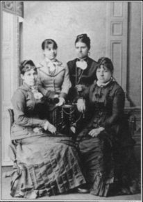
Eagle Woman's four daughters in about 1880. From left to right, Lulu Picotte Harmon, Annie Galpin, Alma Galpin Parkin, and Louise Picotte DeGrey-Von Solen
Mrs. Parkin's sister was Marie (Louise) Van Solen. Their mother, Waŋblí Ayútepiwiŋ/Wambdi Autepewin/Eagle Woman That All Look At, born 1820 in a lodge on the east bank of Big Bend on the Missouri River, was the daughter of Two Lance, a chief of Two Kettle band. She grew up on the plains in present day South Dakota. She married twice to white men, lived at fur trading posts, and learned the ways of white men and taught them the customs of her people. She was a pivotal figure in her community at a time when many changes were occurring, a female chief, and the first woman to sign a treaty with the US government in 1882. Waŋblí Ayútepiwiŋ worked for nonviolent solutions to racial conflicts and was a good diplomat. Waŋblí Ayútepiwiŋ/Eagle Woman and her daughter Louise organized the first day school at Standing Rock Indian Reservation. She continued aiding the tribes in adjusting to reservation life until her death in 1888. In 2010, she was inducted into the South Dakota Hall of Fame.
A side note that I could not help noting= Eagle Woman's first white husband, Canadian fur trader Honoré Picotte (they married 1838), also had another Indigenous bride (1829) along with a white wife. He fathered Eagle Woman's first 2 daughters (Marie being one), then left both Indigenous woman and settled with his white wife in St. Louis in 1848. Not to be undone, in 1850, Eagle Woman married Picotte's protégé at the company, Charles Galpin, with whom she had two more daughters and three sons, all of whom were given a European education. By 1876 we find Eagle Woman, although not signing a treaty for a reservation at that time (she did sign later in 1882), working with Catholic folks to establish a assimilation school (while the rest of the Lakotas fought for their sacred Black Hills), which her daughter ran. Eagle Woman was originally buried at the Fort Yates cemetery. Sadly and unfortunately, no announcement of her death has been found in the papers of the time. In the mid 20th century, she also became another Indigenous person who was displaced, as her burial spot was moved to make way for the construction of Lake Oahe.
In 2016, the location of Eagle Woman's former grave site was one of several disputed as part of the Dakota Pipelines Protests. And even though hers is also an underreported history, she has been called "the most noted Indian woman of all the western Indian nations,' next to Sakakawea."
Lesson learned here: That's how quickly genealogical and cultural history gets messy! Indeed, Eagle Woman also paired up with a white Catholic Priest to try to convince Sitting Bull to move his people to a reservation.
Another lesson: There are always two sides to stories, history, and people. I can't even begin to count the treaties that were made in this whole time period. In the end the established reservation that we know today of over 2.3 million acres of prairie lands in the Great Plains was established and further abuses and governmental attempts at disruption and assimilation continue to this day.
Mrs. Van Solen inherited the Cannon Ball home in which her sister, Alma Parkin, had lived. Marie and her daughter were prominent people of the community. Among other things, Marie is said to have taught the first school on the Standing Rock.
The town of Solen (14 minutes east of Cannonball, population 70) is said to be named after Mrs. Van Solen. It is also (or used to be) a part of the large Parkin Ranch that Eagle Woman and her daughters all lived on.
3rd generation of educators right here! Very dedicated women I believe. It was nice to read and learn about them, even if I didn't exactly find their schoolhouse.
The unidentified site at Parkin Ranch. I could not find a word about it. If anyone knows, drop a line, help a sister out please! I think it is either Cannonball Schoolhouse or No. 1 Schoolhouse
Contemporary Cannonball circa 4/2016-2/2017
The Oceti Sakotin (Seven Council Fires of the Lakota-Nakota-Dakota Oyate or People/Nation) camp was on the Northern edge of Standing Rock near Cannonball River + Missouri River. Water Protectors gathered to protest the Dakota Access Pipeline. At one point this camp spread across 30 acres and was home to about 5,000 Water Protectors. I did not visit this site either, b/c it no longer exists. Burnt down under threat of arrests from DT's first administration. Nor do I care to speak/write/think of the eventual results of this situation. More bad history is how I file it.
The sum of cultural historical site on the north bank of the Cannonball River with a million years of geological history, 700 years of continual occupation, inter-tribal conflict, smallpox, botany, trade, steamboat traffic, US military history, and early ranching have made that location significant.
Views along the trail
Fort Yates, ND
This casino is considered in Fort Yates, even though it is closer to Solen and Cannonball. No I did not go to any casinos on my trip.
At Standing Rock, there are Hunkpapa + Si ha’Sapa Lakota + Yankton Dakota People. The population is composed mainly of Hunkpapa Lakota and Yanktonai Dakota people with around 16,102 enrolled members and an estimated resident population of 8,000.
I had no idea how or where folks were situated on the landscape. I was heading next to the visitors center to get information and permission.
This was the view for a great while as I drove. The river came in and out of view. I definitely felt like I was in the heart of Great Plains habitat on prairie land. I enjoyed the grasslands swaying in the seeming constant wind, despite a 98 degree temperature reading from my rental car.
I passed Slaughterhouse Bay (don't know the origin of the name, but can imagine) and then came upon a structure that looked like a modern school.
It was indeed the backside of the Elementary School. The schools (elementary, middle + high) were all in semi-circular driver as a cluster. I drove on, for old, not new, schools was my search.
This told me I had arrived. But I had no idea of the lay of the land. I turned down 92nd St. and immediately began to feel uncomfortable. I was not going to the visitor's center. I was entering the actual Fort that had been set up on a bluff overlooking the Missouri River. Now home to about 2,000 Indigenous people + I wasn't yet invited in.
 .This is photograph of Fort Yates dated 1875 shows members of the Frontier Army
This Fort was in service from 1863-1903
Standing Rock's earliest years when three officers and 85 men in companies A and F of the U.S. 17th Infantry represented not only military might brought against the Plains Indians but the end of thousands of years of self determination.
The soldiers came, the palisade walls went up and the rules were sent down. No longer could these indigenous people practice their religion and hold their sacred ceremonies.
Undated photo of the town and likely council meetingHard to imagine it as a place, over 300 years ago that held Indigenous Peoples living in Earthen lodges on the exact same spot.
The old Fort's stockade is said to be the only remaining structure of the old fort. Although I know it was also here, try as I might, I could not find any pictures of the Standing Rock Indian Boarding School. There is mention of a fire in the last "old" building from the school in 2024 + proposals out to remediate the exposed asbestos, but no pictures. SO close, but sooo far away.
"Old Sitting Bull College/ Standing Rock Community College (1973) Building from Boarding School days was vacant by 2024 + and fire destroyed."
Old Sitting Bull College was said to be housed in the old Government run Industrial Boarding School. Religious people first cleared an old agency building at Fort Yates, where shortly after Easter, 1877, they opened the first school. Four Benedictine Sisters arrived in 1878 to help in the school. The school was opened as a governmental school under the auspices of the Catholic Church.
Here are some more pictures (from the ND State Historical Society) that are likely from Standing Rock Indian Boarding Schools:
Warring continues, resistance continues, but slowly assimilation efforts begin to get the upper hand.
During the summer and fall of 1876, many Indians filtered back to their various agencies while those who stayed in the un-ceded lands were relentlessly hunted down by the army. In a tense meeting with government officials in October 1876, Sitting Bull refused to surrender and stated that the Great Spirit had made him an Indian, but not an agency Indian. Rather than go to the reservation, he led his people northward into Canada in January 1877.
In the fall and winter of 1876 and 1877, all Indians returning to their agencies had to surrender their guns and horses to the Army. At Standing Rock, all Indians who lived some distance from the agency had to move closer to the administrative office so the agent and soldiers could watch them. The Indigenous People were now confined to their reservation and were regarded as prisoners of war. Firm control was exerted on all the inhabitants of the Great Lakota/Dakota Reservation, including those people at Standing Rock Agency.
Schools came. Day and Boarding. Native-run and Religious-run. Overarching theme's= governmental intervention + assimilation is the goal. Fort Yates had St. Scholastica Indian Boarding School in 1878.
Fort Yates and Kenel (in South Dakota) were the two sites where the missionaries, together with the governmental agencies, first established formal educational centers.Agricultural School Standing Rock Agency; Fort Yates, Dakota; Standing Rock Agency circa 1888 I think the above 2 pictures are from the same 100+ acre farm school run by Martin Kenel. In 1879, Abbot Martin Marty, stationed at Fort Yates, applied to the federal government for a tract of land to open an agricultural school for boys. Those Benedicts sure did get around, especially in Indian Country back in the day.
McLaughlin, SD circa 1926 St. Bernard Mission School. I wanted to go to McLaughlin, not to see Bernard Mission school, but to see if I could visit the Earthen Lodge created by the Defenders of the Water School (co-created by two righteous Indigenous WOMAN!!!).
Dang it all for a July 4th travel day. Nothing open; no permissions granted.
Here is a PBS video about the cool-as-shit Defenders of the Water School. I was wishful thinking of running away and joining them in this student-led, project-based alternative school.
The Defenders School starts at 6:45 and goes until 10:15
So let me tell you what I did do in Fort Yates:
I drove straight down 92 until I felt my skin crawl for the first time EVER (I am usually pretty calm about trespessing) + a foreboding feeling set in my gut. I stopped my car here. I knew that there had been Indian Boarding Schools in Fort Yates, but I also knew they no longer existed, so I really had no business in being there.
On closer inspection I knew I was near the alleged first burial site of the Hunkpapa Lakota spiritual leader Tatanka Iyotaka. "Eh, who cares" I told myself- the prodigious cemetery troller. I saw the water tank in the distance so I snapped a shot to check later, turned the car around and drove off.

Yup, I was still on the land. Somewhere in the middle of Standing Rock and many many more miles to go. So where the hell was that visitor's center + new college?
I was still pretty enamored with the openness of Great Plains and the mightiness of the Missouri River so I drove on marveling at the vista's. Before I knew it, I espied a sign. A BIG sign!
Then there I was at the big new sign that had a rolling electronic board of info. but was a tad hard to read in the bright light. I did not bring sunglasses to wear on this trip even though I had been in big sky country previously in Montana + environs.
An impressive super clean campus and also super closed for the day(?), summer (?) place. No movement at all.
We/I already had learned of the beginnings of this college in the town of Fort Yates, but did not know about this modern campus. The original name was Standing Rock College with a name change in 1996 to Sitting Bull. Also, it has gone from community college to full on college, with Bachelors + Masters Programs. Go SBC! This campus began in 1999 at this site and has steadily grown over the years.
...and here is the lovely visitor's center that I drove for hours to get to. Built in 2013, it was were I had hoped to get some of my questions and permissions dealt with, and also spend some of my tourist dollars. Damn it all for best laid plans. Drove on again.
Eased on down the road and crossed states, driving into:
SOUTH DAKOTA
Kenel, South Dakota
Was in Kenel South Dakota when I spotted the alien abduction site. Okay, so my mind wandered a bit on the long journey. I knew Kenel was named after a priest and that this was the site of the Indian Agricultural Boys School in 1879 (Called St. Benedict Indian School)-1961, but no school to be seen on this day.
Cover of a book written about this mission.
Here is a picture of intricate paper weaving found in the scrapbook.
In 2015, the Marshfield Historical Society of Marshfield, Massachusetts donated an 1895 scrapbook from their collections that had originally been created by students at the Agricultural Boarding School in Kenel, South Dakota. The collection consists of essays and student work in beautiful handwriting as well as artwork consisting of drawings, woven paper, crochet and weaving.
Don't you just wonder who, what, and why this scrapbook ended up in Marshfield, MA??? I do. Alas, I likely will never find out :(

As I drew closer, I also decided this was not a potential alien abduction (don't get me started... big foot sightings... I could easily rabbit-hole it here) site. It was a water tank. Random Factoid: All 27 Indian boarding schools in South Dakota were run by christian churches.
Next stop: Wakpala, SD
I passed by the church down the road, knowing it was once associated with St. Elizabeth's School (1886-1967). There was no marker so I did not stop (it is now hotter than ever + moments out of the car produced rivers of sweat). The chapel is the origin place for the day school that started there. The boarding school didn't come until 1885. What I do know about the school was that it included leadership of "converted" Indigenous folk who agreed with and enforced the missionary ways of eliminating old Indian ways (i.e. strict harsh treatment carried on and out by Indigenous people- so sad, IMHO). 
Hunkpapa Lakota girls drying dishes at St. Elizabeth's Mission School (c. 1900)
This Episcopal Church and Mission Boarding School was the first I had heard about a protestant school in a sea of catholics in this part of the country.
Throughout history, various missionary societies, including Catholic and Protestant groups, sought to integrate Native Americans into European-American ways of life through education and religious conversion. Talk about a painful and conflicted history. These institutions, believing in what they were doing, thought they were helping, but their actions were often misguided and resulted in significant cultural disruption. When the feds got co-joined with them, oh boy! The stories are continuing to come out to this day. Not all are bad, but the subject is still raw as exposure of "more accurately true" history is being agitated for.

Even though it was now approaching 100 degrees, I still had to get out and read the markers, and now you can too!
This is the school I spent way too much time on trying to find. Way up North (like in ND).

I hope the education today meets the needs of the community and the old Indian school mentality is a thing of the past.Interestingly enough, just down the road a bit I came to this. Not only was it open on the 4th of July, unlike most everything else, but it also was a "secure" facility as I learned the minute I walked through the door.here is a video on the place:
The Great Plains Area Youth Regional Treatment Center provides drug and alcohol treatment for adolescents ages 13 - 17 years of age who are enrolled as a member of a federally recognized American Indian tribe. They have 18 beds and have been in service since 1998. I did not take a picture of the facility (fear), but the buildings are in a distinctive style like the far left structure.
They wouldn't let me use the bathroom so I had to drive down to the end + a weird little almost shoreline small camping ground had a camp store. Then it was time to cross a bridge.
Places on the Reservation I didn't visit:
Grand River, SD
The road diverged, I went left across the Missouri River at the great convergence of rivers and the bottom of the current reservation boundaries of the federal government (including the HUGE Oahe Reservoir and Lake). Had I gone right and followed the Grand River I could have visited the alleged Sitting Bull Camp Site as well as the small town of Little Eagle/Waŋblí Čik'ala, Sd (pop. about 370). Both places were once areas or "camps of resistance" (against being reservationized). Sadly, we know the fate of Sitting Bull/Tatanka Iyotaka. Also, we know that there was/is also an Indian Boarding School out that way too.
This the school in the early 20th century

The Little Eagle Grant School was formerly known as the Sitting Bull School (until 2016), and its history was documented in a 1975 book created by the Little Eagle Community History and Development project. The current Little Eagle Grant School is a tribally operated/affiliated school. They have an embedded history booklet on the school website (which I have a healthy skepticism about its truthfulness). It was written in 1975 by an Adele F. Little Dog
Basically, a white woman, Mary Clementine Collins came from Illinois and spent thirty-five years of her life as a missionary to Indians. She began her mission work at Oahe, South Dakota, and then went out on her own at Little Eagle, South Dakota, on the Standing Rock Reservation in 1885. Whether this is propaganda or not, it is alleged (according to Mary Collins archives in the SD Historical archives) "Mary was well acquainted with the Hunkpapa Sioux leader Sitting Bull. Even though he did not have much use for missionaries, Sitting Bull came to respect Mary enough to adopt her into his tribe as his daughter." What is known is that once started, this school was temporarily shut down due to the brouhaha caused by Tatanka Iyotaka and the controversial Ghost Dancing that had the feds and white folk quaking in their shoes.
I don't think I need to point out the non-Indian in this picture. This is not an uncommon picture to BIPOC communities around the U.S. that were "allowed" to get public education, even today!
From Adele F. Little Dog's pamphlet:
This, IMHO, is a concise, albeit short summary of what happened on the Great Plains.


No comments:
Post a Comment