After we took the left turn onto Highway 18, the topography changed. Still had rolling hills, but now more vegetation and trees.
This small community came to be called Fairfax in 1903 when a railroad was built that passed right through the Osage Reservation. The RR bypassed the Osage village of Grey Horse (more on that at a future blog).
The Osage had/have many bands and their numbers and ancestral lands have diminished. They were displaced, evicted, and infected (smallpox epidemic) in their tumultuous history since European contact. Long before their arrival in the "Indian Territory," they had been trading and intermarrying with French traders. Other white immigrants soon arrived and set up trading posts amongst the Osage on their "new" reservation land in Oklahoma. Marriage "alliances" had been going on for some time, and as such their were many "mixed bloods" around the region. A white merchant who was among the Osage in Grey Horse, Lew A. Wisemeyer, was the person who finagled a deal to start the town of Fairfax on 40 acres. He also was instrumental in getting the newly formed railroad to bypass Grey Horse and stop in Fairfax. Oh those ambitious capitalist white men!
This looked like an old well that was once upon a time used as advertisement as well. We were unsuccessful at guessing at any of the old, faded lettering.
I'm sure the sign likely was an advertisement to entice the driver to come to town for some sort of service. As the intermingling of peoples happened more and more at the turn of the 20th century, you find European cultural dominance in many ways. Education was largely "missionary" run with an unspoken tenet to inculcate the Indians to European ways (in language, dress, etc.), land ownership was shifted from tribal to individual allotments, and more and more marriage alliances were happening. However, the Osage are resilient people. They had/have traditions they have passed on through the generations and have blended new traditions for modern times. We came to see what was out in the rural Osage land.
This property is right before the "Welcome to Fairfax" sign. No way to make out what it is/was. A ranch? Is it Osage owned? The nuanced history of the area and lack of people to ask made it hard to figure out much of what we were seeing.
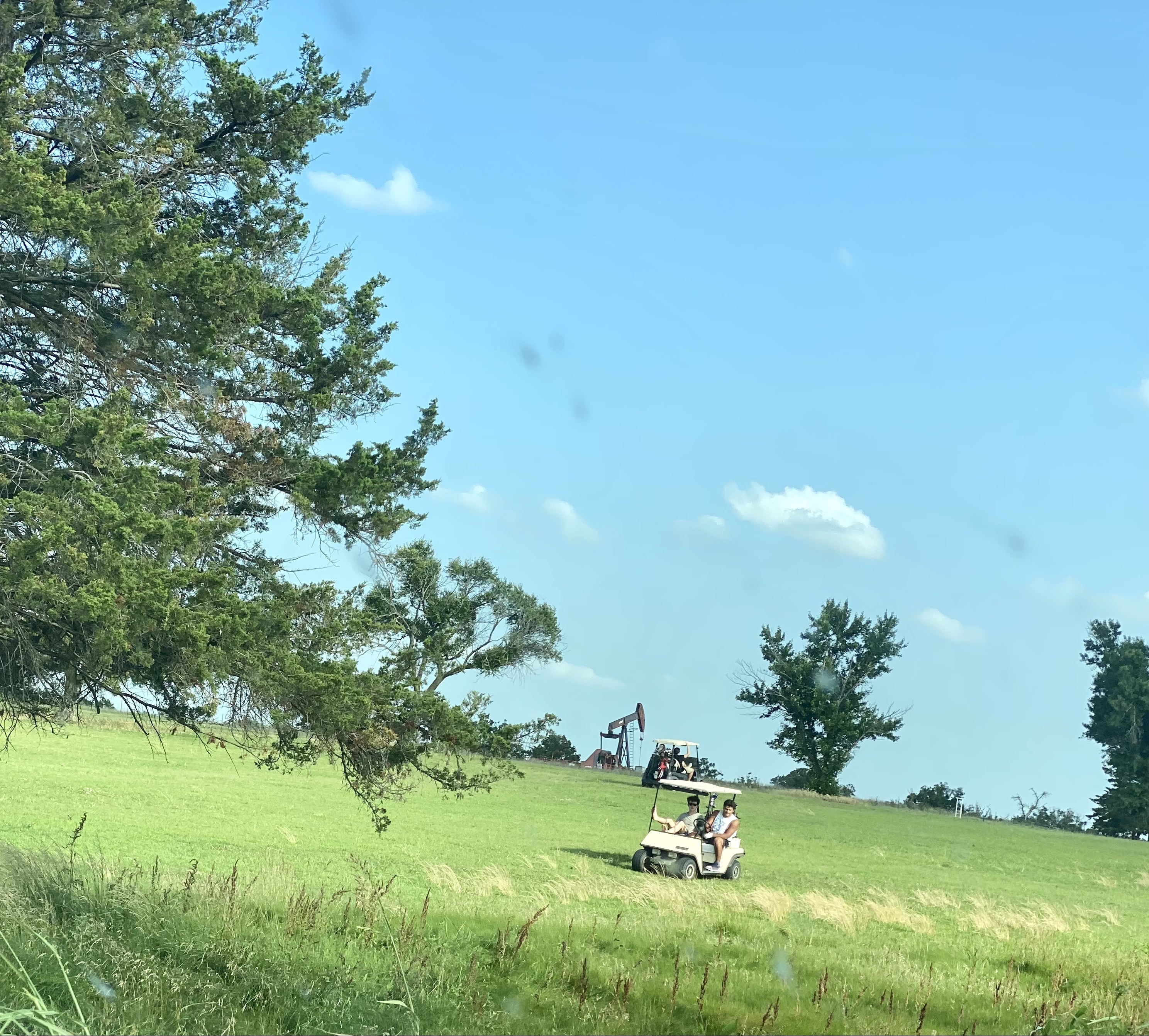
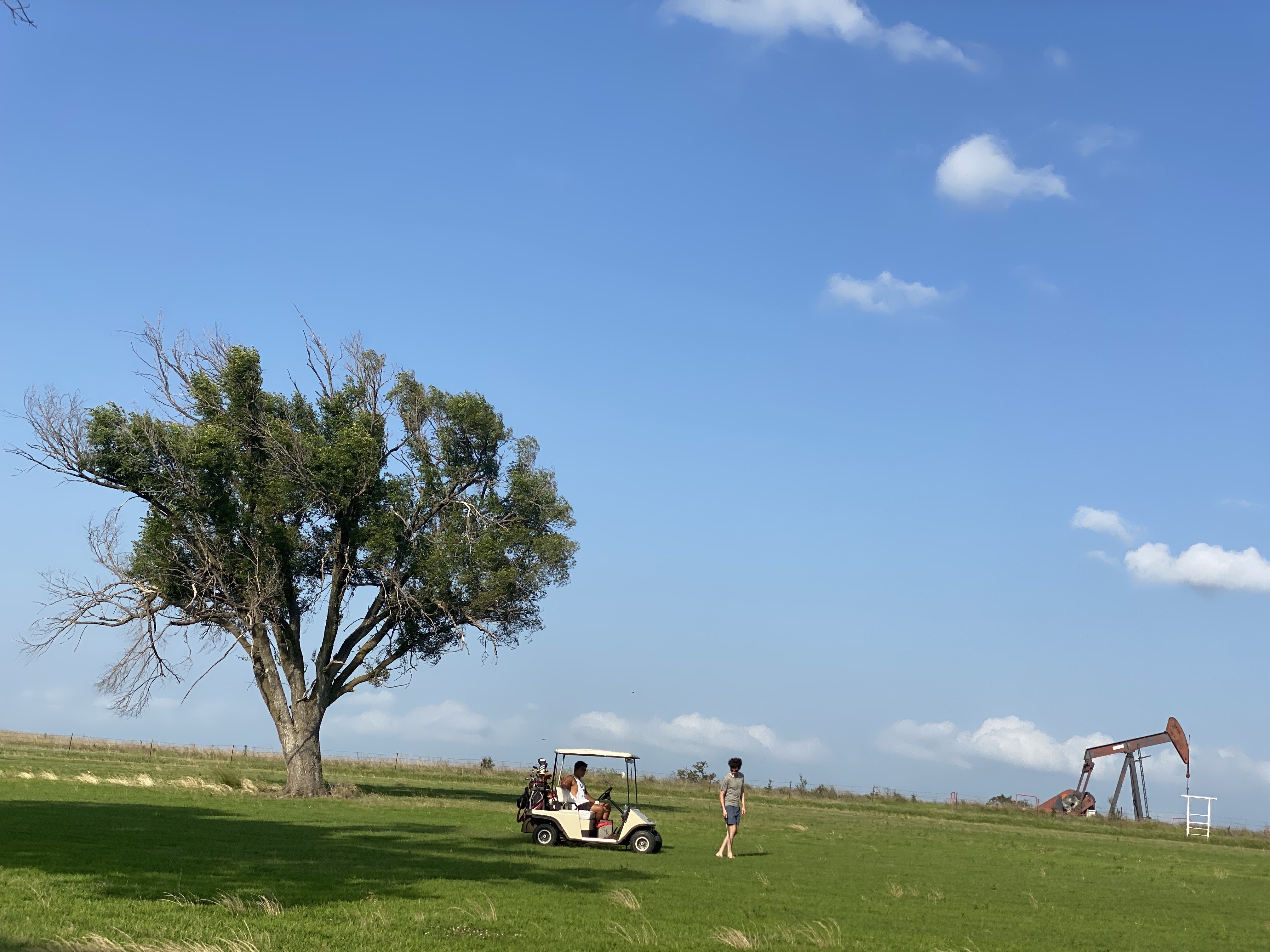
Kah-Wah-Z is a public, 9-hole golf course designed by Chief Yellowhorse in 1922. By this time, the oil boom, marriage alliances, "adoption of" or acculturation to Anglo practices led to many changes in the way indigenous communities lived. Many of the Osage adopted some of the trappings of our USA classist practices such as elite golf courses with country clubs.
We were astounded, amazed, and amused to see a working derek on the course. An indication to us the importance that oil has in certain areas of our country. Such a huge construct to wrap my New England brain around.
Definitely gawkers, with car idling and iphone at the ready, but these youthful golfers didn't seem to mind.
It's been a year since I traveled out there, and still I struggle for the words to describe what I saw, the feelings that came up/still exist, and how little I really know about spaces and places in the USA.
I heard a story. A remarkably sad and almost unbelievably true one. It involved what humans actually do to one another. Not in war times. Not in conflict. But not exactly peace either. Have we ever really had peace?
The Osage Plains, Osage People, Osage Nation, Osage County, and Osage, Oklahoma are all both very interconnected and not at all the same.
First the plains: they are a part of the vast central lowlands of North America and cover 4 states (western MO, southeastern KS, central OK, and north-central TX). The traditional Osage Lands stretched even further than these 4 states (a huge part of OK,KS, MO, AK, with a dip into Texas on top, and LA on bottom).
We were in the area of central OK and traveled to the outer rims of Missouri and Kansas.
Time, discovery and exploitation of natural resources, changes in land ownership through treaties, theft, and sales, along with encroachment, displacement, and downright murder have really changed a great deal of the social fabric in the area, as I am sure climate change and man-made changes have altered the area, but let me just share in pictures the vastness of what it means to be out in the plains:
The vast area in Oklahoma is further subdivided into regions. The central plains are also known as the "Tallgrass Prairie."
The "Tallgrass Prairie," is an area of broad rolling hills and tall grasses. I never realized how many different kinds of grasses there are in the world as well as in different regions. This region, has its own ecosystem that once covered almost 200 million acres of land. Now there is less than 4% of this land left (most turned into farmland as you see above).
"Tallgrasses were the area's predominant vegetation until the late nineteenth century when white settlers began clearing land for agriculture and wood. Among the tallgrasses that survived the settlement era include big bluestem (Andropogen gerardii), little bluestem (Schizachyrium scoparium), Indian grass (Sorghastrum nutans), and switchgrass (Panicum virgatum)."
"The Osage Plains lay in both Indian Territory (eastern Oklahoma) and Oklahoma Territory (western Oklahoma). After land openings and tribal land allotment took place, by the beginning of the twenty-first century towns and cities dotted the Osage Plains. Farming, ranching, and petroleum production have been the dominant economic activities."
Two surprise learnings: 1. Even though it was extremely hot when we were there, on the plains, the wind always seemed to be blowing, and 2. I knew all about the oil on the land from book reading and prior knowledge, but the wind turbines were unexpected.
Once upon a time this was a big brewhaha in the area that made the news (2014). Sadly it was a controversy that once again pitted white farmer folk against Osage Indians concerned about the Eagles the turbines could kill.
Oil derricks dot the land all over Oklahoma, but wind turbines are relatively new. This farm (owned by a Bush from Texas who used to be in oil and gas accounting. Hmmm..., I wonder?) is in fact tied up to the largest rancher family in the area, the Drummonds (a whole different and disturbing story we learned of from our "guided tour" in Pawhuska in which the female guide truly and freely displayed her prejudices with some pretty racist remarks about the Drummonds vs. the Osage Indians and how "we" have taken almost all of "their" land), and is a border property to the smaller Osage Indian towns we had set out to visit.
An odd juxtaposition of old and new technology on the land.
Cattle ranching with a twist (or is it a turn)! This ranch is abutting Osage Nation land. As earlier mentioned, there was opposition to this new technology. However, the Osage, environmentalists, and other concerned landowners have not prevailed over time.
The Osage Nation are a Native American tribe. Their ancestral lands have been greatly reduced, but they are a Federally recognized tribe with tribal lands, a reservation, and their own tribal government.
The name "Osage" comes from the early French traders. It was the French version of the Osage word "Wa-zha-zhe", which means "Children of the Middle Waters." Early Osage hunted as well as farmed, and lived in many small bands or groups around the region. They still live in many different places around Oklahoma and the U.S. Locally, tribal headquarters are in Pawhuska.
See older blog:https://kendraedmonds4.blogspot.com/2021/10/sojourn-2021-bearing-witness-or-seeking.html
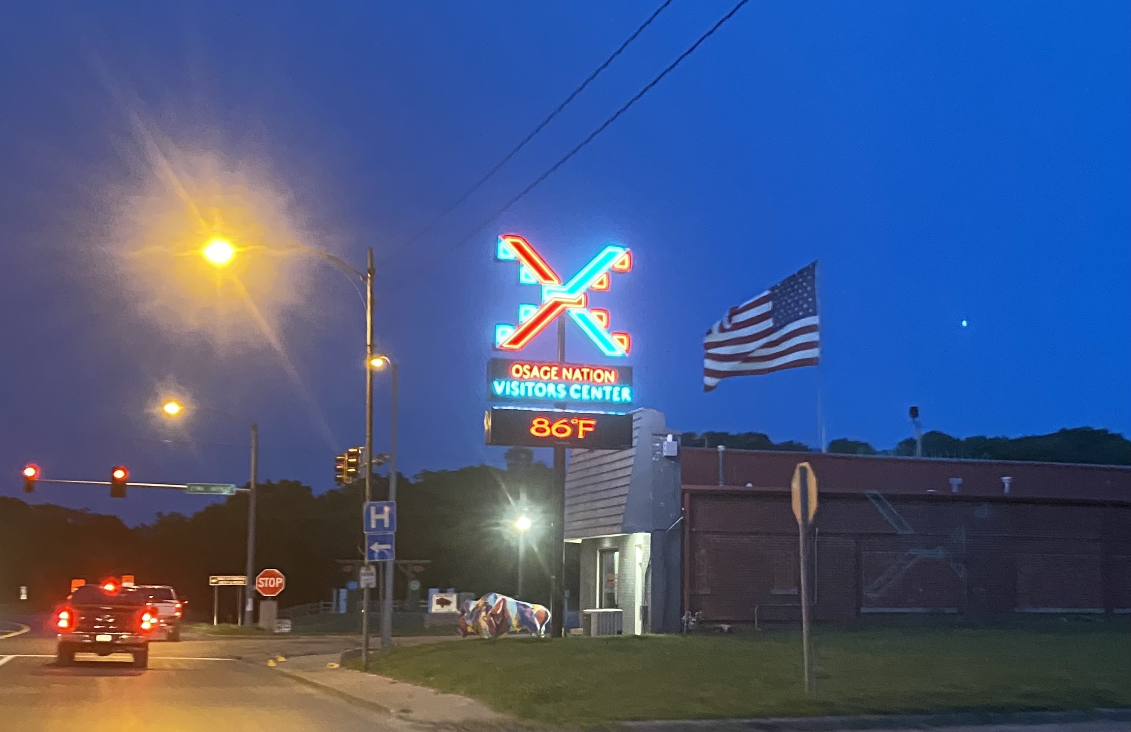
The Osage Nation (/ˈoʊseɪdʒ/ OH-sayj), "People of the Middle Waters" have a visitors center in Pawhuska
But I really was somewhat traumatized by all the hoopla, white tourists, along with the overshadowing by the Merchantile Store, Drummond woman/tv personality, awful guided tour, that frankly I was too embarrassed to go into any of the Osage Nation places that I had for years waited to visit.
Instead we drove to the outside towns where the actual drama of the book/soon-to-be movie took place. The Osage have a Reservation that they themselves bought from our federal government on land they had been forced to move from and then back to (so confusing and complex it all was/is to me) that basically is all of Osage County. They have about 1,470,000 acres- a great deal of land is leased out.
Much has been done to the Osage people as the U.S. (and by this I mean white men from history-critical race theory ban in Oklahoma BE DAMNED!) acted out its "manifest destiny" and pushed for more and more: land, power, and overall rule of the land. Critical governmental actions (Indian Removal Act) were devastating. Followed by the Dawes Act (subdividing tribunal communal land into allotments) and there you have the basic dismantling of strong Native American/Osage reservations and attempts to destroy tribal government. I was happy to see that the Osage Nation had both an active government and license plate. I was unhappy that we saw very few tribal activities and/or people from the Osage community.
I bet you are wondering about the numbers, I know I was. Originally, the Osage set up 3 towns: Pawhuska, Hominy, and Fairfax. Pawhuska has about 3,500 people of which 31% are Native American (approx. 1,000). Hominy also has about 3,500 with about 25% Native American (875) and Fairfax about 1,400 with about 24% Native American (336). So there you have it: manifest destiny wins. BUT... they are still there. Maybe not in the numbers they once were, but...STILL.THERE.
We took the left turn and headed to the older places and spaces where the bad things happened.
We had the opportunity to travel for a bit on the old Rt. 66. Touched on it in and around Tulsa, but then drove for quite some time in a vertical Northeast direction out of Oklahoma, touching into Kansas, and traveling on to sleep in Missouri. Sometimes it was hard to tell where state and/or tribal lines where.
This town is named after a tribe of Indians that was once a part of a much larger group of Sioux named Dhegiha. The descendants were originally from the Ohio Valley. Others from this language group are also now in Oklahoma territory as independent nations.
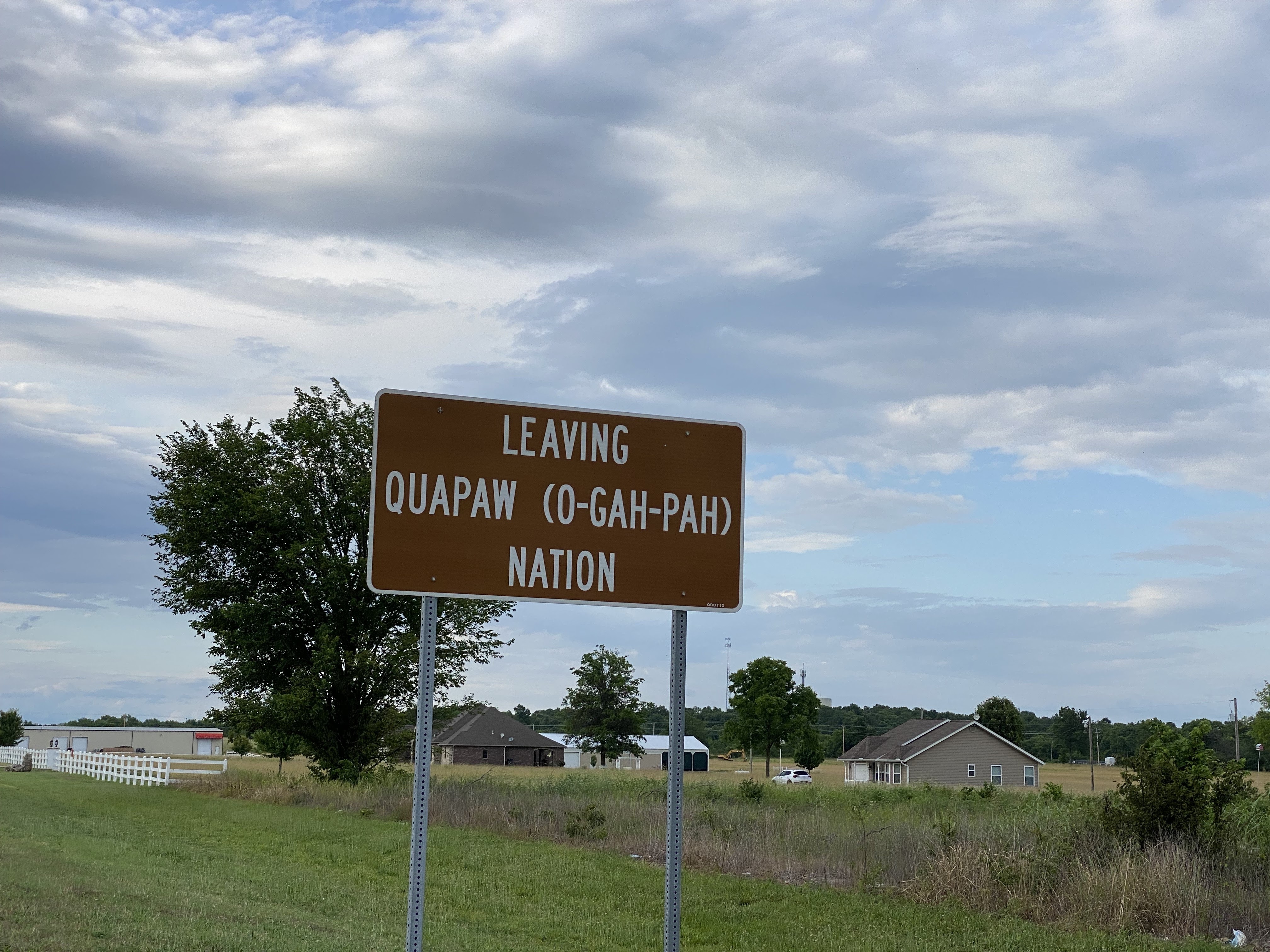
Quapaw is the last town before entering Kansas. It was Indigenous settled in the late 1800's (after governmental removal in 1834), but the discovery of the lead and zinc mines in the region in the early 20th century brought thousands of miners to the area. The town is not very large population-wise (< 1,000), but the Quapaw tribe have a 13,000 acre tribal jurisdictional area and about 230 Quapaw living in the town.
This is North Main St. and believe it or not, this was once a restaurant.
Not sure if the Cafe survived the Pandemic (we saw many shuttered places), but some business-minded youth had set up a lemonade stand next door. Yes we bought some.
On a side street this sweet craftsman style house was found. I love making that turn and finding a gem.
Somebody (Republicans if you were wondering as I was) bought this 1910 house for $63k and did a fantastic job of rehabbing it.
The Quapaw Nation and Quapaw town, we discovered are not one and the same.
Way off in the distance, even though the sign said we were leaving Quapaw (nation?/town?) we could see the huge casino that we thought was Quapaw run.
And sure enough, as we got closer we saw the name- the Downstream Casino Resort. "Downstream People" is what Quapaw people are known as.
O-Gah-Pah is how you say Quapaw in the tribe's language.
The Casino grounds were super clean and tidy.
But inside the cigarette smell made us feel pretty ill. It has been years since Massachusetts has allowed indoor cigarette smoking. In the bathroom at the casino I found these condoms, which gave me a chuckle.
This marker was right before the state line on the Oklahoma side. Honestly, at that point, I didn't know if we were in Kansas or Missouri.
This sign wasn't very helpful. I thought we had left Cherokee Nation a while back. The town Cherokee, OK is more Northwestern. Also, there are 14 places in the U.S.A. named Cherokee so we were a little confused. Let's try Cherokee County that should tell us something. Yup, ahuh, ok- there is Cherokee County in GA, and also in N.C., S.C. But there is also a Cherokee County in Kansas, so we were found!
In the nineteenth century, the nation’s focus was on the Missouri-Kansas border, where peoples with different definitions of freedom collided, inciting and fueling a Civil War.
When Kansas was opened for settlement in 1854, a border war ensured, capturing the nation’s attention. The Kansas-Nebraska Act nullified the uneasy balance established by the Missouri Compromise and left the territory’s future slave status in the hands of settlers. The stakes were high for both sides. The violence of the Missouri/Kansas Border War ushered in the Civil War, consumed the region in bloody conflict through the war's end, and devastated communities on both sides of the border.
What is "Freedom's Frontier?" That was new learning for me. A place of a border war= do they teach about this border war in our New England history textbooks? I can't remember. Apparently right on the border of Missouri and Kansas, which is where we were there was a border war. "Bleeding or Bloody Kansas" the border war was called. It was rooted in the violent struggle to get Kansas to be a slave state (1854-1859), which didn't happen. Anti-slavery was the victor and Freedom's Frontier was born!
Freedom's Frontier National Heritage Area includes the sites of extraordinary events that forever changed America.
Even as I struggled with the signage, I sort of had the feeling were in Kansas, and the next sign bore me out.
And just like that, there it was again. Of course we were back on good 'ole Route 66, and yes Dorothy, we were in Kansas!
Apparently we were in Baxter Springs, KS a small town right on the border. We did not see a rainbow bridge or even remember driving over any kind of water. It was likely a "crick" we cackled to each other, foolishly trying to adopt a prairie accent and pronounce "creek" the way we heard folks say it.
Of course I loved this wall art! And no, I did not find any bricks here. But the whole little downtown seemed to be made out of bricks.
Baxter Springs, KS really wasn't anything exciting to look at unless you like bricks, which of course I do. The little downtown in this bigger than other little towns @ 4,200k population, is the most populous city of Cherokee County. It has a history that is very similar to the many we had already passed through on our trip. The exception being that there were Osage Indians in this territory prior to the "Removal" times as they had been chased to the plains from Ohio Valley in Kentucky by the Iroquois around the mid-17th century. The US Government deemed this area "Cherokee territory" when they removed the tribe to here. As in other places a mixed bag of Indians and white settlers set up a trading post.
Once again, finding a cool side street rehabbed house was fun. It is even a historic house at that!
This is what the original Rial A. Niles house looked like, with its hip roof and cupola (Italianate style) It was built in 1870 for a local businessman and his wife. It has gone through many iterations and was even once a church! Now it is a private residence once again.
That about ended our Plains States Route 66 journey.
My husband was the first to observe that there were differences in the license plates as we drove around Indian Territory/Oklahoma. There are at least 16 different tribes that call this state "home." The legal status of these plates varies by tribe, with some being recognized by the federal government and others not.
Today, the Cherokee Nation is the largest tribe in the United States with more than 390,000 tribal citizens worldwide. More than 141,000 Cherokee Nation citizens reside within the tribe’sreservation boundariesin northeastern Oklahoma.
This one line from early research at the Oklahoma Historical Society still resonates in my brain:
"The Cherokees were the largest slaveholders among Native American nations, according to the Oklahoma Historical Society."
I was and am so conflicted over this. I had a tough time driving through the Cherokee Nation and was glad to be leaving it as we drove on into the night. I did a couple "fuck you's" and "how could you cry about your trail of tears when you had black folk doing the heavy lifting," and drove on. Very distinct childhood memories kept flooding back- the black side of the VA family getting bragging rights for their nice hair and Cherokee heritage. I was so confused now. Even tracing the black folks who "settled" on the frontier became muddled. Were they "freedmen," descendants of the enslaved by Indians or "pioneers," freed folks from the Whites after the Civil War who came to squat and "claim" (some would argue steal) land to start to make a life for themselves.
Another interesting article talks about further indignities the Cherokee visited upon black folk when they kicked them out and off the governemental doles claiming they weren't "true blood." This expulsion wasn't in the 19th century, it happened in 1983 and legal battling continues to this day. Not to mention, as our family did often enough, the "mixed bloods" who actually do have some Indigenous blood in them.
Bye bye Cherokee Nation, I won't see you again. A bit surprised at my feelings, but there they were...
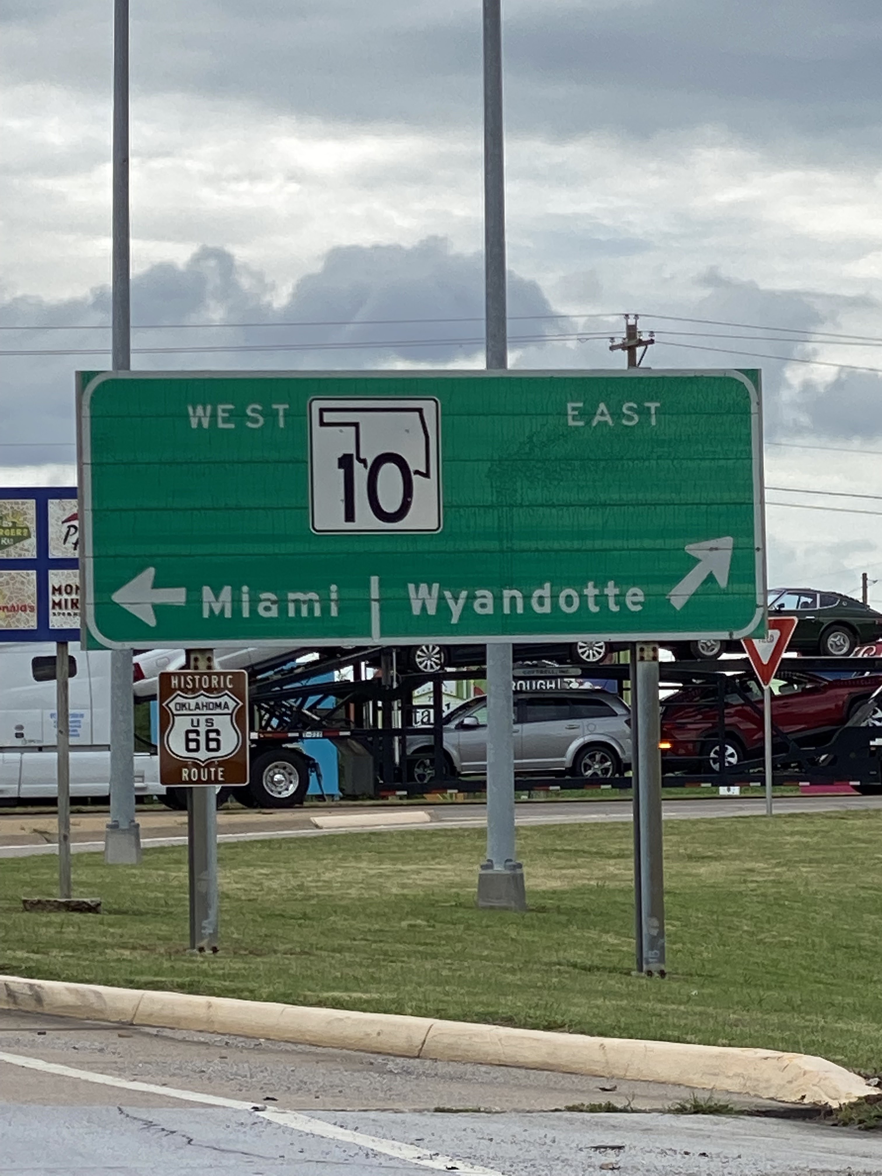
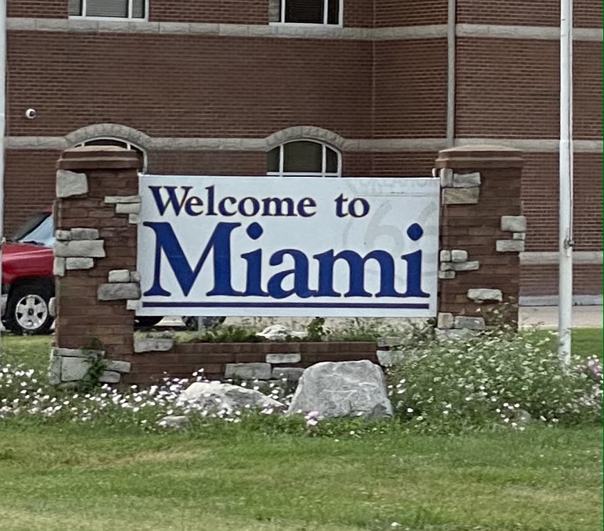
No not Florida, Miami Oklahoma.
Nine Native American tribes are located in or near Miami; Quapaw Tribe, Wyandotte Tribe, Modoc Tribe, Miami Tribe, Seneca-Cayuga Tribe, Ottawa Tribe, Eastern Shawnee Tribe, Peoria Tribe, and Shawnee Tribe.
A small city that was also part of Indian Territory. It has rolling prairies that we travelled through a bit before we hooked up to the Historic Route 66. The county is named Ottawa. Both the Ottawa and the Miami were on the land when a white man came along and bought about 600 acres and the town was born in 1891. Known for lead and Zinc mines in the area, this created the "boom" to grow this town.
Sadly, historic Woody's diner from 1930's didn't make it thru the pandemic.
Miami is known more now for tourism, but you can tell the town has seen hard times
Cute little touristy things to be found on Rt.66. This chapel has been around since 1954.
In 1991, Route 66 Cultural District teamed up with 10 artists to create the history of the town in Murals.
NEO began as the School of Mines in 1919 and is now called the Northeastern Oklahoma A&M College.
Imagining a prairie home from 1925. It was estimated to cost $76k in 2021.
One of Miami's big tourist attraction is Coleman Theatre-built in 1929 by local mining magnate George Coleman. The theatre has a distinctive Spanish Colonial Revival exterior.
As you leave "historic" Rt. 66 Main St. Oklahoma, another picture emerges. This vacant site is 2 acres large. It last was a retail place called "Treasure Hunt" that sold salvage items.
And sadly yes there is an ubiquitous "Dollar General" in this scruffy, rundown part of Miami, OK. Who knew what happened to the business on the right. It didn't look like new damage, but just old damage left to decay.


 This looked like an old well that was once upon a time used as advertisement as well.
 This property is right before the "Welcome to Fairfax" sign. No way to make out what it is/was. A ranch? Is it Osage owned? The nuanced history of the area and lack of people to ask made it hard to figure out much of what we were seeing.

 Kah-Wah-Z is a public, 9-hole golf course designed by Chief Yellowhorse in 1922. By this time, the oil boom, marriage alliances, "adoption of" or acculturation to Anglo practices led to many changes in the way indigenous communities lived. Many of the Osage adopted some of the trappings of our USA classist practices such as elite golf courses with country clubs.
  We were astounded, amazed, and amused to see a working derek on the course. An indication to us the importance that oil has in certain areas of our country. Such a huge construct to wrap my New England brain around.
  Definitely gawkers, with car idling and iphone at the ready, but these youthful golfers didn't seem to mind.

 The clubhouse, like the course, was not your average Country Club. It seemed pretty chill.
 Sporting the parked older truck which we saw a great deal of in many yards and businesses.